GEOGRAPHY: Staring at Houston: Does Lake Pontchartrain = Galveston Bay?

All we know right now that unless some sort of pool of frigid water bubbles up from the depths of the Gulf of Mexico, the hot surface water temperatures of the Gulf are going to maintain Hurricane Rita as a monster storm. Where ever Rita hits -- and my bets right now are on Brazoria or Galveston counties in Texas ... assuming the high pressure system that’s parked over the Southeast United States doesn’t do anything wacky in the next 72 hours -- it’s going to be bad. Look at what little-ole Tropical Storm Allison did to Houston in 2001 (above).
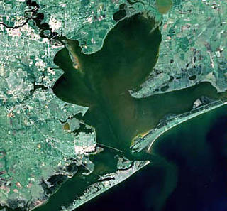
Some of the forecasts model take the eye of the storm to an area just to the southwest of Galveston. The closer the northeastern quadrant of the eye wall makes it to Galveston, the more devastating Rita will become. Just consider the geography.
 Behind Galveston sits Galveston Bay, and behind it the miles of bayous and low-lying swampy land that infiltrate Houston, Harris County, more than 5 million people and a 25-mile-long port complex that "is ranked first in the United States in foreign waterborne commerce, second in total tonnage, and sixth in the world." That’s right, more oil refineries that could be knocked off line for months to come ...
But let’s forget the oil and the economic consequences for just a second. Just as the Times-Picayune predicted a dire situation for New Orleans’ worst-case scenario, the Houston Chronicle too has considered its city's "Big One".
Houston's perfect storm would feed on late summer's warm waters as it barreled northward across the Gulf of Mexico, slamming into the coast near Freeport.
A landfall here would allow its powerful upper-right quadrant, where the waves move in the same direction as the storm, to overflow Galveston Bay. Within an hour or two, a storm surge, topping out at 20 feet or more, would flood the homes of 600,000 people in Harris County. The surge also would block the natural drainage of flooded inland bayous and streams for a day or more.
Coastal residents who ignored warnings to flee would have no hope of escape as waters swelled and winds roiled around their homes. Very likely, hundreds, perhaps even thousands, would die.
Sound familiar? Could Rita be a Carla, the post-1900-benchmark storm for the Houston region?
Fortunately, Houston sits slightly above sea level. But for anyone who has been to Houston well knows, it is not a dry place. One thing you will notice while driving the Sam Houston Tollway on the far outskirts of Houston’s exurbs are the great heights of its highway interchanges. Depressed highways don’t do so well in an area with such a high water table, so in grand Texan style, the highway interchanges soar higher than most Midwestern downtowns. It’s an impressive feat of engineering that’ll hopefully lead people away from of harm’s way. But that won’t do much to prevent a massive storm surge from inundating Galveston Bay and the Houston Ship Canal.(I just checked high tide for Saturday morning, and in Galveston Bay, they only seem to be 1.5-2.5 feet. Then again, I am no expert at tidal dynamics.
 But any high tide timed with a high storm surge is a bad combo.)
When I was in Houston in the fall of 2002, I had the pleasure of touring Transtar, which is the Houston area’s transportation and emergency management center. Its control room is simply amazing, with a huge control room, live camera footage and map displaying water gauges throughout the area. I had happened to be there during a time of flooding, and lights were blinking in one part of the county where the water was rising. Despite
 the minor emergency, Metro Police Chief Tom Lambert (left) took me and my colleagues at the time out for a fantastic Mexican lunch. From what I saw first-hand at Transtar, Harris County and Houston seem to be better prepared for such an emergency than New Orleans was. (But then again, New Orleans with Katrina was facing a doomsday geographic and hydrological scenario.) But after lunch, I couldn’t help notice how close the drainage ditches on the side of the highway sit to the restaurant. Houston is a saturated place. Mix in Rita, shake and stir, and the results are troublesome.
What does Brendan Loy -- who has been popularized as the blogger from South Bend who predicted the size and scope of the Katrina disaster as the storm was approaching the Louisiana coast -- have to say about Rita? Category 5:
Now, obviously Katrina has changed the panic vs. preparedness equation somewhat, as suggested by my padawan post and my dad's observation (confirmed by what I'm seeing on CNN in the airport terminal) that the cable news networks and even The Weather Channel are taking a "hair on fire" approach to Rita. Still, to see the NHC making such a statement in the discussion, this far in advance, suggests to me that they're very concerned about this storm. Speaking on the phone just now with a fellow weatherblogger (I'm not identifying him because I don't know if he meant his comments to be "on the record" or not, but he can identify himself in comments if he wants), he agreed and said, "Basically, that means it's going to be a Cat. 5, but they don't want to say that because they don't want to hit the 'panic' button."Then again, it could go further south or east of the Houston area, so all guesses this far in the game are suspect. But they are uncomfortable nontheless.
Image of Tropical Storm Allison in Houston flooding from the city of Austin
Image of Galveston Bay from NOAA
Image of TransStar from the Federal Highway Administration


0 Comments:
Post a Comment
<< Home